A-5: Difference between revisions
Pbcjohnston (talk | contribs) Added captions and moved photos |
Pbcjohnston (talk | contribs) mNo edit summary |
||
| Line 48: | Line 48: | ||
[[File:A-5 San Diego Map.jpg|left|500px]] | [[File:A-5 San Diego Map.jpg|left|500px]] | ||
This chart, although drawn up by the 11th Naval District in 1923, will still give a good reference to what is seen in the Pike photo above. The | This chart, although drawn up by the 11th Naval District in 1923, will still give a good reference to what is seen in the Pike photo above. Two sight lines have been drawn on the map by Ric Hedman to indicate features seen in the photo above. The photo was taken from approximately the location indicated on the map of anchorage #78, in the main channel between San Diego and Coronado. This chart gives a good visual reference to how the San Diego area was laid out in the early 20th Century. Point Loma was largely barren with only the Army’s Fort Rosecrans at Ballast Point, along with a small Navy fueling depot just to the north of the fort. Naval Air Station North Island was still quite small, taking up only the northern 1/3 of the island, with the Army’s Rockwell Field making up the southern portion. The old Spanish Bight can be clearly seen, dividing North Coronado from South Coronado. Today it is the site of the base golf course. Note also the complete absence of NAB Coronado, just south of Glorietta Bay and Hotel Del Coronado. In later years, San Diego International Airport would be built on backfill over the old Dutch Flat at the north end of San Diego Bay. | ||
<small>NARA Image #295436 in the public domain.</small> | <small>NARA Image #295436 in the public domain.</small> | ||
Revision as of 17:48, 20 October 2023
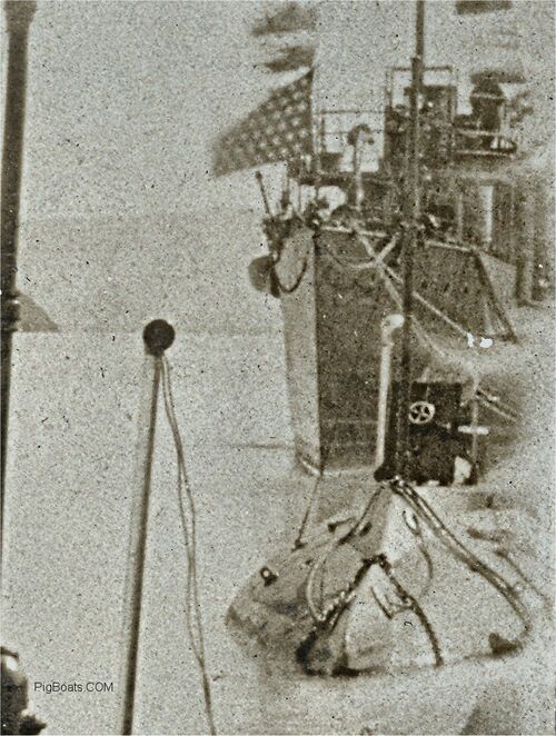
An original NON-Navy photo in the private collection of Ric Hedman.
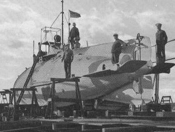
Pike hauled out on a marine railway, location unknown, but likely at the Mare Island Navy Yard, Vallejo, CA., approximately 1905. The man on the far right is standing on one of the stern diving planes.
Photo in the private collection of Ric Hedman.
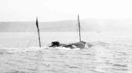
Pike surfacing after a submerged run in the shallow waters of Carquinez Strait, just off Mare Island, CA., circa 1906. The water is just deep enough for her to run just below the surface with a little to spare. This is a safe thing to do in case of an accident.
Photo in the private collection of Ric Hedman.
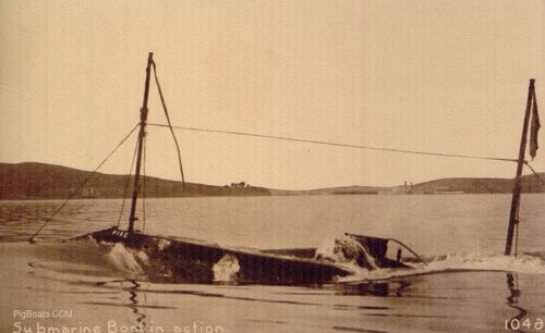
Another photo of Pike taken at about the same time as the one above. This was probably a little farther out in San Pablo Bay. The term "pigboats" came in part from the fact that these early boats, in the days before periscopes, had to broach frequently in order for the CO to be able to see where he was going. Old timers thought that this frequent broaching and diving looked a lot like a swimming porpoise, which they referred to as "sea pigs".
Photo in the private collection of Ric Hedman.
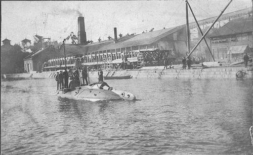
Pike leaving the dock at the Mare Island Navy Yard, approximately 1906. As usual, most of her crew is topside to escape the noise and stifling conditions below. Mare Island was one of two major shipyards on the west coast of the United States, the other being the Puget Sound Navy Yard in Bremerton, Washington.
Photo in the private collection of Ric Hedman.
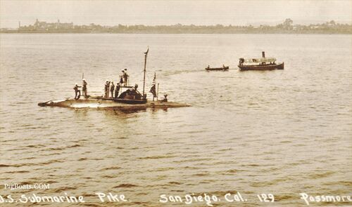
Pike seen here circa 1905 in San Diego Bay on the east side of Coronado Island. The view is looking west out to the Pacific Ocean. On the left background is the Hotel del Coronado. The hotel was built in 1888 and has been a major fixture of San Diego since then and even staring in a number of Hollywood motion pictures. On the photo's right above the motor launch, seen faintly above and beyond the closer shoreline, is a faint headland. This is believed to be Point Loma. The Point Loma Light House can just be seen on the tip of the land.
The sub seems to be just sitting still. It appears a small boat has just departed and is joining a larger steam powered motor launch. It looks like the whole crew is topside. The design compliment was one officer and six enlisted, though the sub may have had a few more than designed.
In 1905 Coronado Island was actually composed of two land masses, North and South Coronado, neither of which was a full island. They were known as “tied islands” as both were connected to the mainland by the narrow Silver Strand beach running to the south to Imperial Beach. North Island (the eventual NAS North Island) was separated from South Island (the city of Coronado) by a small shallow inlet called the Spanish Bight. In addition, NAB Coronado at the south end of Glorietta Bay didn’t exist yet as over 90% of the land associated with it was composed of backfill dredged from the harbor in the early 1940’s. The Bight was filled in 1944 to form the peninsula that we know today.
Photo in the private collection of Ric Hedman.
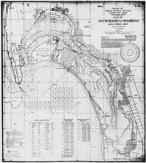
This chart, although drawn up by the 11th Naval District in 1923, will still give a good reference to what is seen in the Pike photo above. Two sight lines have been drawn on the map by Ric Hedman to indicate features seen in the photo above. The photo was taken from approximately the location indicated on the map of anchorage #78, in the main channel between San Diego and Coronado. This chart gives a good visual reference to how the San Diego area was laid out in the early 20th Century. Point Loma was largely barren with only the Army’s Fort Rosecrans at Ballast Point, along with a small Navy fueling depot just to the north of the fort. Naval Air Station North Island was still quite small, taking up only the northern 1/3 of the island, with the Army’s Rockwell Field making up the southern portion. The old Spanish Bight can be clearly seen, dividing North Coronado from South Coronado. Today it is the site of the base golf course. Note also the complete absence of NAB Coronado, just south of Glorietta Bay and Hotel Del Coronado. In later years, San Diego International Airport would be built on backfill over the old Dutch Flat at the north end of San Diego Bay.
NARA Image #295436 in the public domain.
USS Pike (Submarine No. 6) crew muster for 1911. Data is incomplete due to lost records.
•Donavin Kirkwood H. - Ensign - age 23 - Born: Ohio
•Ryan Raymond - CGM - age 25 - Born: Ireland
•Essig William H. - CEM - age 25 - Born: New York
•Schroeder, Gustave A. - GM 1c - age 27 - Born: Wisconsin ~ Drowned in F-1 grounding, 1912.
•Ertel, Edward G. - MM 1c - age 29 - Born: Germany
•Bucom, Roy E. - EM 1c - age 24 - Born: Missouri
•Myrick, Lester B. - EM 1c - age 24 - Born: Maine
•Ethrington, William J. - MM 1c - age 34 - Born: Michigan
•Kautcke, Wendel - MM 1c - age 33 - Born: Indiana
•Murphy, Robert W. - GM 2c - age 32 - Born: Connecticut
•Ward, Charles A. - MM 2c - age 34 - Born: New York
Thank you to Linda Talbott of the US GenWeb Census Project® for providing this information.
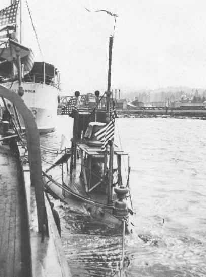
Pike on the Willapa River, at Raymond, Washington, circa 1911-1912. The A-class subs were fitted with a bow fairing to improve sea keeping, this can be seen by the dark shadow area forward of the conning tower. Pike was placed in reserve in 1912 at Bremerton. This photo was probably taken on the trip up the coast to Bremerton. The stern of the USS Chattanooga (Cruiser No. 16) can be seen in front of the sub.
Photo provided by Steve Hubbard of the Pacific County Historical Society, Washington State.
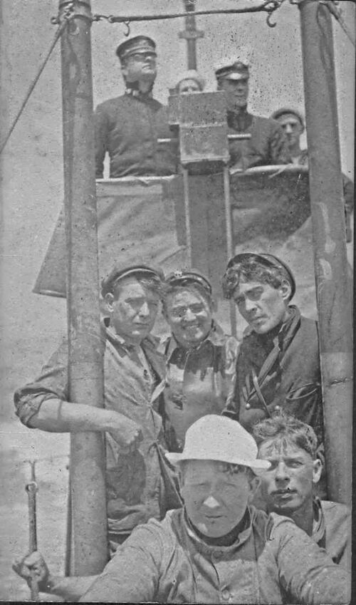
Pike and her crew topside, approximately 1911. The location is unknown but assumed to be near San Francisco. The officer on the right on the bridge is probably the commanding officer, Ensign Kirkwood H. Donavin.
Photo in the private collection of Ric Hedman.
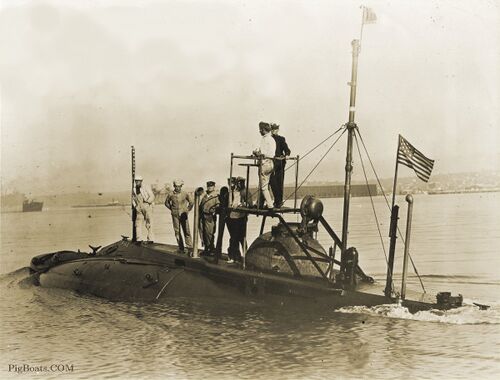
Pike is seen here near San Francisco, 1911. Ensign Donavin and six crew are topside to pose for the camera. It is an excellent photo that shows the men's faces, (of those not in shadow). This is one of those photos that remind us that submarines were not just about the steel of the hulls but also about the flesh and blood that manned them. Since Pike is wearing the name "Pike" this photo was taken in 1911 before the name change.
The helmsman, standing next to Donavin, seems to be smoking a pipe. The position of his hand and the long thin stem looking object pointing up in a manner suggesting a pipe. Note, that the shaft for the helm extends down into the pressure hull. It mates up to the below deck helm. The topside helm is removable and was usually stored outboard the torpedo tube inside the hull.
The two men in shadow in front of the bridge seem to be officers and more likely are day riders. The flag at the top of the periscope looks to be a squadron flag and has the numeral "1" on it. One of the men may be the Commodore of the 1st Submarine Group, Pacific Torpedo Flotilla, Ensign James Perdue Olding and possibly his aide. One man is wearing a necktie and both are wearing officer's caps.
There looks to be one Chief topside. The crew was mostly made up of rated personnel. The Navy was taking only volunteers and seemingly the most experienced in rate at that time. The Chief standing between the two ventilators is either Gmc Raymond Ryan or EMC William H. Essig. These two men were known to have been aboard during the time frame of this photo but no identified images of either man has been found.
The tall pole is actually the periscope. These early periscopes were fixed and only pointed forward. They did offer some collision protection by allowing the submarine to be deeper and not needing to broach to see out of the deadlights in the conning tower. At the base of the periscope is the magnetic compass binnacle. They were placed above and as far away from the steel hulls as possible. The compass was viewed through a series of mirrors. Just behind the conning tower near the “X” bracing for the bridge is the ships air whistle.
Photo coutesy of Darryl Baker.
Page created by:
Ric Hedman & David Johnston
1999 - 2023 - PigBoats.COM©
Mountlake Terrace, WA, Norfolk, VA
webmaster at pigboats dot com
