Harbor Light: Difference between revisions
No edit summary |
Pbcjohnston (talk | contribs) (Format updates to links) |
||
| (10 intermediate revisions by 2 users not shown) | |||
| Line 1: | Line 1: | ||
[[Category: | [[Category:Photo Features]] | ||
[[File:Header | [[File:Header light station.jpg]] | ||
[[File:Red bar sub new.jpg]] | [[File:Red bar sub new.jpg]] | ||
=== <big>Honolulu Harbor Light Station</big> === | === <big>Honolulu Harbor Light Station</big> === | ||
<div style="text-align: justify;"><span style="color:#00008B"> | <div style="text-align: justify;"><span style="color:#00008B"> | ||
[[File:Honolulu light-1.jpg||left| | This page grew over time as more information was learned and more photos and drawings became available. This becomes evident as you read the page its growth and progression can be noted. | ||
Photos of The Honolulu Harbor Light Station are very hard to find. PigBoats.COM has spent several years trying to track down better images of this very distinctive and lovely building that played such a large part in the early history of | [[File:Honolulu light-1.jpg||left|500px]] | ||
Photos of The Honolulu Harbor Light Station are very hard to find. PigBoats.COM has spent several years trying to track down better images of this very distinctive and lovely building that played such a large part in the early history of U.S. submarines in Hawaii. Each time a submarine or Navy ship or merchant vessel entered or left the harbor the light was there, day or night, to guide them safely in or out. The time has finally arrived and some clear and close-up views of the building have now become available. | |||
When the first submarines, the USS F-1, F-2, F-3 and the ill-fated | When the first submarines, the USS [[F-class|'''F-1, F-2, F-3 and the ill-fated F-4''']], arrived in Hawaii they were moored in Honolulu Harbor since Pearl Harbor was merely a coaling station with little or no facilities that could accommodate submarines. A base there, for submarines, wouldn't be available until 1920/21. In the mean time the Navy leased piers 5 and 5A in the commercial harbor. The following images and map hopefully will show the lighthouse and submarines in relationship to each other. | ||
In this first photo, three of the four F class submarines are moored at pier 5 and seen at the left is the | In this first photo, three of the four F class submarines are moored at pier 5 and seen at the left is the Honolulu Harbor Light Station at the inner harbor mouth. To the right, at Sand Island, is the Quarantine docks and building where inbound vessels were first docked and checked by a medical examiner to be sure nothing contagious was being brought into the islands. | ||
The | The F-4 shown here on the right sailed past this light for the last time under her own power at 0915 AM on Thursday March 25, 1915. She had submerged near the Quarantine wharf with it abeam and sailed past the Honolulu Light at a depth of 18 feet and down the channel. The last person to see the F-4 was Ensign Harry Bogusch, XO of the F-1. While standing on the deck as she returned to port he witnessed the F-4's periscope trained on him at about 0945. He waved his hat at it. He reported all seemed well with the submarine. That was the last she was seen before her salvage on August 30, 1915. | ||
<center>=== '''Honolulu Harbor Light Station''' ===</center> | <center>=== '''Honolulu Harbor Light Station''' ===</center> | ||
''"In 1906, plans were proposed for the transition from a simple, primitive light in Honolulu Harbor to a permanent, efficient light station. The following year, the harbor was dredged, providing a deeper port for large ships. Material created from the dredging was added to the existing Quarantine Island, that in turn was called Sand Island. It was on Sand Island that the Honolulu Harbor Light Station was built. The beacon went into service on February 15, 1910. Although of vital importance to all shipping in the Islands, it did not compete with its far more romantic and visually appealing sister light towers on | ''"In 1906, plans were proposed for the transition from a simple, primitive light in Honolulu Harbor to a permanent, efficient light station. The following year, the harbor was dredged, providing a deeper port for large ships. Material created from the dredging was added to the existing Quarantine Island, that in turn was called Sand Island. It was on Sand Island that the Honolulu Harbor Light Station was built. The beacon went into service on February 15, 1910. Although of vital importance to all shipping in the Islands, it did not compete with its far more romantic and visually appealing sister light towers on Oahu. After several years, the sturdy building, that had become the well-known Honolulu Harbor Lighthouse, almost resembled a home, complete with a gate and white picket fence. The lower portion of the structure provided living accommodations for two light keepers. The lofty illuminating apparatus above the dwelling housed the necessary guiding light for all ships entering the busy harbor..."'' | ||
The light atop the Honolulu Harbor Light Station on Sand Island was removed and placed atop the newly built | The light atop the Honolulu Harbor Light Station on Sand Island was removed and placed atop the newly built Aloha Tower in 1926 and could be seen out to sea for a distance of 15 miles. The Honolulu Harbor Light Station building was destroyed in 1934. | ||
'''CAROL EDGECOMB BROWN Frederick Albert Edgecomb: A Lighthouse Service Career, Hawai'i 1911 to 1942''' | '''CAROL EDGECOMB BROWN Frederick Albert Edgecomb: A Lighthouse Service Career, Hawai'i 1911 to 1942''' | ||
| Line 24: | Line 25: | ||
[[File:Red Star Line.jpg]] | [[File:Red Star Line.jpg]] | ||
[[File:Honolulu light-2.jpg||left| | [[File:Honolulu light-2.jpg||left|500px]] | ||
This close-up of the lighthouse is very grainy but it does show some of the architectural charm of the structure. The cupola holding the light dominates the roof-line. | This close-up of the lighthouse is very grainy but it does show some of the architectural charm of the structure. The cupola holding the light dominates the roof-line. | ||
| Line 31: | Line 32: | ||
[[File:Red Star Line.jpg]] | [[File:Red Star Line.jpg]] | ||
[[File:Honolulu light-3.jpg||left| | [[File:Honolulu light-3.jpg||left|500px]] | ||
At the inner end of the Honolulu channel was the Honolulu range light shown here in a September 21, 1904 photo This is the light that will be replaced by new building seen below. The attached structure was undoubtedly for a light keeper lodging. A clipper bowed hulk can be seen between the building and light structure. | At the inner end of the Honolulu channel was the Honolulu range light shown here in a September 21, 1904 photo This is the light that will be replaced by new building seen below. The attached structure was undoubtedly for a light keeper lodging. A clipper bowed hulk can be seen between the building and light structure. | ||
<small>Courtesy of | <small>Courtesy of [http://www.uslhs.org '''U.S. Lighthouse Society archive''']</small> | ||
[[File:Red Star Line.jpg]] | [[File:Red Star Line.jpg]] | ||
[[File:Honolulu light-4.jpg||left| | [[File:Honolulu light-4.jpg||left|500px]] | ||
It has been a long hard search and still no clear photo but we have finally come up with a set of lines drawings that are located in the National Archives for the "Front Range Light" as proposed on October 6, 1906. Later to be popularly known as the Honolulu Harbor Light Station. This being the Front elevation facing the harbor and the island itself. | It has been a long hard search and still no clear photo but we have finally come up with a set of lines drawings that are located in the National Archives for the "Front Range Light" as proposed on October 6, 1906. Later to be popularly known as the Honolulu Harbor Light Station. This being the Front elevation facing the harbor and the island itself. | ||
| Line 50: | Line 51: | ||
[[File:Red Star Line.jpg]] | [[File:Red Star Line.jpg]] | ||
[[File:Honolulu light-5a.jpg||left| | [[File:Honolulu light-5a.jpg||left|500px]] | ||
This is the End Elevation with the Front of the building to the Right. The Entrance and Bath Room roof lines can be seen as gables on the main roof. The light tower, built of of poured concrete, can be seen to be located to the right or shoreward side of the roof peak. | This is the End Elevation with the Front of the building to the Right. The Entrance and Bath Room roof lines can be seen as gables on the main roof. The light tower, built of of poured concrete, can be seen to be located to the right or shoreward side of the roof peak. | ||
| Line 60: | Line 61: | ||
[[File:Red Star Line.jpg]] | [[File:Red Star Line.jpg]] | ||
[[File:Honolulu light-5.jpg||left| | [[File:Honolulu light-5.jpg||left|500px]] | ||
This is the Back Elevation showing the smaller window in the Bath Room Extension. The Bath Room was a shared facility between the two residences. | This is the Back Elevation showing the smaller window in the Bath Room Extension. The Bath Room was a shared facility between the two residences. | ||
| Line 68: | Line 69: | ||
[[File:Red Star Line.jpg]] | [[File:Red Star Line.jpg]] | ||
[[File:Honolulu light-6a.jpg||left| | [[File:Honolulu light-6a.jpg||left|500px]] | ||
This plan view shows the interior layout with the mirror image residences. The light tower base and a storeroom separate the two giving a measure of privacy. | This plan view shows the interior layout with the mirror image residences. The light tower base and a storeroom separate the two giving a measure of privacy. | ||
| Line 78: | Line 79: | ||
[[File:Red Star Line.jpg]] | [[File:Red Star Line.jpg]] | ||
[[File:Honolulu light-6.jpg||left| | [[File:Honolulu light-6.jpg||left|500px]] | ||
The first image shows the lighthouse front. The side facing the harbor of Honolulu. The place where much of the land that the lighthouse is sitting on came from. The differences from the lines drawings and the as built photos shows the front no longer has the gable end over the door. Probably to save construction monies. The small building with the flat roof this the oil storage building providing fuel for cooking and heating plus oil for the beacon on top. The fluting in the pilasters has been removed in favor of a smooth surface. | The first image shows the lighthouse front. The side facing the harbor of Honolulu. The place where much of the land that the lighthouse is sitting on came from. The differences from the lines drawings and the as built photos shows the front no longer has the gable end over the door. Probably to save construction monies. The small building with the flat roof this the oil storage building providing fuel for cooking and heating plus oil for the beacon on top. The fluting in the pilasters has been removed in favor of a smooth surface. | ||
Freshly planted trees are seen growing and blowing in the tropical winds. A picket fence surrounds the structure. Behind the buildings is the harbor entrance channel and to the right is the open Pacific ocean. The rough ground is reclaimed soil from the bottom of Honolulu Harbor. | Freshly planted trees are seen growing and blowing in the tropical winds. A picket fence surrounds the structure. Behind the buildings is the harbor entrance channel and to the right is the open Pacific ocean. The rough ground is reclaimed soil from the bottom of Honolulu Harbor. | ||
To the left in the far background is the | To the left in the far background is the Young Brothers boathouse. The Young Brothers company is still in business today. | ||
<small>Photos Courtesy of the U.S. Coast Guard Historian's Office via Candace Clifford, Historian, U.S. Lighthouse Society | <small>Photos Courtesy of the U.S. Coast Guard Historian's Office via Candace Clifford, Historian, U.S. Lighthouse Society archive</small> | ||
[[File:Red Star Line.jpg]] | [[File:Red Star Line.jpg]] | ||
[[File:Honolulu light-7.jpg||left| | [[File:Honolulu light-7.jpg||left|500px]] | ||
The | The Young Brothers boathouse with two of their launches seen moored in front of the building which is built on stilts on the side of the entrance channel. What appears to be the launch/tug "Louise" is on the left and the tug "Makaala" is on the right. Young Brothers is still operating today as a tug and barge company. This company was very instrumental in the recovery of the submarine F-4 after it sank at the mouth of Honolulu Harbor. Their tugs are noted in many of the salvage and recovery photos associated with the F-4. | ||
<small>Photos Courtesy of the U.S. Coast Guard Historian's Office via Candace Clifford, Historian, U.S. Lighthouse Society. | <small>Photos Courtesy of the U.S. Coast Guard Historian's Office via Candace Clifford, Historian, U.S. Lighthouse Society.</small> | ||
[[File:Red Star Line.jpg]] | [[File:Red Star Line.jpg]] | ||
[[File:Honolulu light-8.jpg||left| | [[File:Honolulu light-8.jpg||left|500px]] | ||
This is a 1915 view of the back of the building. The date is actually November 10, 1915. The center part protruding back is the single bathroom for the building. The two apartments shared a single bathroom. At this time bathrooms were still a "modern" invention. Most of the world still used outhouses. To have indoor plumbing, even sharing it, was still considered luxury. Not seen on the plans but evident in the photo are back doors and stairs. | This is a 1915 view of the back of the building. The date is actually November 10, 1915. The center part protruding back is the single bathroom for the building. The two apartments shared a single bathroom. At this time bathrooms were still a "modern" invention. Most of the world still used outhouses. To have indoor plumbing, even sharing it, was still considered luxury. Not seen on the plans but evident in the photo are back doors and stairs. | ||
The navy ship in the background is the USS Maryland | The navy ship in the background is the [https://www.navsource.org/archives/04/acr8/acr8.htm '''USS Maryland (Armored Cruiser No. 8)''']. Based on the date it is fair to say that she has just escorted some K-class submarines to Honolulu to replace the remaining 3 F-class and to tow the F-3 back to the mainland. The F-1 and F-2 were towed by other ships. The Maryland had brought the six pontoons from Mare Island to Hawaii for lifting the sunken F-4. | ||
<small>Photos Courtesy of the U.S. Coast Guard Historian's Office via Candace Clifford, Historian, U.S. Lighthouse Society | <small>Photos Courtesy of the U.S. Coast Guard Historian's Office via Candace Clifford, Historian, U.S. Lighthouse Society archive</small> | ||
[[File:Red Star Line.jpg]] | [[File:Red Star Line.jpg]] | ||
[[File:Honolulu light-9.jpg||left| | [[File:Honolulu light-9.jpg||left|500px]] | ||
This December 15, 1919 view of the the Honolulu Harbor Light Station show several things. The most interesting is the presence of a small child playing in the yard. The child is seen to the right of the door and stairs and just to the right of the second pilaster. The detail is not there to determine if this is a girl or boy but what is clear is that at least one of the two light keepers who lived at the Light Station had a family with small children. The second interesting thing is there are two small palm trees now growing on either side of the bottom of the stairs. The tops can just be seen over the top of the picket fence. The Pacific Ocean is behind the building. | This December 15, 1919 view of the the Honolulu Harbor Light Station show several things. The most interesting is the presence of a small child playing in the yard. The child is seen to the right of the door and stairs and just to the right of the second pilaster. The detail is not there to determine if this is a girl or boy but what is clear is that at least one of the two light keepers who lived at the Light Station had a family with small children. The second interesting thing is there are two small palm trees now growing on either side of the bottom of the stairs. The tops can just be seen over the top of the picket fence. The Pacific Ocean is behind the building. | ||
<small>Photos Courtesy of the U.S. Coast Guard Historian's Office via Candace Clifford, Historian, U.S. Lighthouse Society | <small>Photos Courtesy of the U.S. Coast Guard Historian's Office via Candace Clifford, Historian, U.S. Lighthouse Society archive</small> | ||
[[File:Red Star Line.jpg]] | [[File:Red Star Line.jpg]] | ||
[[File:Honolulu light-10.jpg||left| | [[File:Honolulu light-10.jpg||left|500px]] | ||
If there had been viable color photography circa 1915 this is probably what the Light Station would have looked like. Thanks to the rendering by Seattle Architect Ron Lloyd, using the drawings seen above, we have this color concept, made exclusively for PigBoats.COM, of how the building might have looked. | If there had been viable color photography circa 1915 this is probably what the Light Station would have looked like. Thanks to the rendering by Seattle Architect Ron Lloyd, using the drawings seen above, we have this color concept, made exclusively for PigBoats.COM, of how the building might have looked. | ||
| Line 119: | Line 120: | ||
[[File:Red Star Line.jpg]] | [[File:Red Star Line.jpg]] | ||
[[File:Honolulu light-11.jpg||left| | [[File:Honolulu light-11.jpg||left|500px]] | ||
A view from the land based Range Light at the Customs House. The view shows the Quarantine Dock on the right side of the photo and to the left of the lights is the Honolulu Harbor Light Station. The photo is undated but it could be estimated to having been take about 1920 give or take a few years. | A view from the land based Range Light at the Customs House. The view shows the Quarantine Dock on the right side of the photo and to the left of the lights is the Honolulu Harbor Light Station. The photo is undated but it could be estimated to having been take about 1920 give or take a few years. | ||
The electric light was the upper light and the gas light the lower one. If you look closely through the open door to the top lantern you can see the old clear light bulb that was used. | The electric light was the upper light and the gas light the lower one. If you look closely through the open door to the top lantern you can see the old clear light bulb that was used. | ||
<small>Photos Courtesy of the U.S. Coast Guard Historian's Office via Candace Clifford, Historian, U.S. Lighthouse Society. | <small>Photos Courtesy of the U.S. Coast Guard Historian's Office via Candace Clifford, Historian, U.S. Lighthouse Society.</small> | ||
[[File:Red Star Line.jpg]] | [[File:Red Star Line.jpg]] | ||
[[File:Honolulu light-12.jpg||left| | [[File:Honolulu light-12.jpg||left|500px]] | ||
The detailed view from the beacon looking down on the Light Station with the lens of the lower gas lantern seen in some detail. As electricity was still new the more reliable "gas" light was included in tandem as a safety feature.. | The detailed view from the beacon looking down on the Light Station with the lens of the lower gas lantern seen in some detail. As electricity was still new the more reliable "gas" light was included in tandem as a safety feature.. | ||
<small>Photos Courtesy of the U.S. Coast Guard Historian's Office via Candace Clifford, Historian, U.S. Lighthouse Society. | <small>Photos Courtesy of the U.S. Coast Guard Historian's Office via Candace Clifford, Historian, U.S. Lighthouse Society.</small> | ||
[[File:Red Star Line.jpg]] | [[File:Red Star Line.jpg]] | ||
[[File:Honolulu light-13.jpg||left| | [[File:Honolulu light-13.jpg||left|500px]] | ||
A Harbor Map from 1909 showing the proposed location of the Light Station and and piers. The location of the Ranging Light seen above can be seen at the end of the dotted line running from the bottom of the map and up to the shaded building cluster. The beacon was located just the north of the Customs House and east of the future location of the Aloha Tower. As noted on the map it is a Flashing Green beacon light. | A Harbor Map from 1909 showing the proposed location of the Light Station and and piers. The location of the Ranging Light seen above can be seen at the end of the dotted line running from the bottom of the map and up to the shaded building cluster. The beacon was located just the north of the Customs House and east of the future location of the Aloha Tower. As noted on the map it is a Flashing Green beacon light. | ||
<small>Photos Courtesy of the U.S. Coast Guard Historian's Office via Candace Clifford, Historian, U.S. Lighthouse Society. | <small>Photos Courtesy of the U.S. Coast Guard Historian's Office via Candace Clifford, Historian, U.S. Lighthouse Society.</small> | ||
[[File:Red Star Line.jpg]] | [[File:Red Star Line.jpg]] | ||
[[File:Honolulu light-14.jpg||left| | [[File:Honolulu light-14.jpg||left|500px]] | ||
This map from the book "Undersea Valor" by Willard F. Searle, jr and Thomas Gray Curtis, jr, shows how Honolulu Harbor looked in 1915 when the Honolulu Harbor Light Station was in use. The shaded areas on the left are sand dredged up from the channel and harbor bottom to make the harbor a safe depth for all shipping using it. The Honolulu Harbor Light Station was built on this reclaimed land as noted on the map. The long causeway leading to the actual "Quarantine Island" from the Quarantine dock can be seen leading to upper left. There people with communicable diseases were housed on the island until cleared for entry. | This map from the book "Undersea Valor" by Willard F. Searle, jr and Thomas Gray Curtis, jr, shows how Honolulu Harbor looked in 1915 when the Honolulu Harbor Light Station was in use. The shaded areas on the left are sand dredged up from the channel and harbor bottom to make the harbor a safe depth for all shipping using it. The Honolulu Harbor Light Station was built on this reclaimed land as noted on the map. The long causeway leading to the actual "Quarantine Island" from the Quarantine dock can be seen leading to upper left. There people with communicable diseases were housed on the island until cleared for entry. | ||
| Line 149: | Line 150: | ||
[[File:Red Star Line.jpg]] | [[File:Red Star Line.jpg]] | ||
[[File:Honolulu light-15.jpg||left| | [[File:Honolulu light-15.jpg||left|500px]] | ||
Another photo taken after March 25, 1915 shows the F-3 and either the F-1 or F-2 moored to pier 5 in Honolulu Harbor. The Honolulu Light Station building can be seen in the background. An unidentified crewman stands on the deck of the F-1 or 2 perhaps talking to someone on another submarine barely seen at the edge of the photo. | Another photo taken after March 25, 1915 shows the F-3 and either the F-1 or F-2 moored to pier 5 in Honolulu Harbor. The Honolulu Light Station building can be seen in the background. An unidentified crewman stands on the deck of the F-1 or 2 perhaps talking to someone on another submarine barely seen at the edge of the photo. | ||
| Line 158: | Line 159: | ||
[[File:Red Star Line.jpg]] | [[File:Red Star Line.jpg]] | ||
[[File: | [[File:The3fs-2 color.jpg||left|500px]] | ||
This photo | This colorized photo was taken at pier 5 in Honolulu Harbor, it was taken after the [[Notable Submarine Accidents|'''F-4 sank on March 25, 1915''']] killing all 19 crewmen aboard during a practice dive. The Honolulu Harbor Light Station can be seen in the background in this undated photo but the time of day this was taken looks to be mid morning based on the lighting on the photo. | ||
The three submarines were prohibited from diving after the pressure hull collapsed on the F-4 from corrosion caused by a battery acid leak killing all 19 crew. The men are cleaning up the subs for a | The three submarines were prohibited from diving after the pressure hull collapsed on the F-4 from corrosion caused by a battery acid leak killing all 19 crew. The men are cleaning up the subs for a Captain's inspection. It was determined to send the three back to the mainland and replace them with the newer K-class submarine coming off the ways at this time. The ships used to tow the K-boats to Hawaii were used to tow these subs back to the mainland. The three F-boats left Hawaii in November 1915. | ||
<small>Photo in the collection of Ric Hedman</small> | <small>Photo in the collection of Ric Hedman</small> | ||
| Line 167: | Line 168: | ||
[[File:Red Star Line.jpg]] | [[File:Red Star Line.jpg]] | ||
[[File:Honolulu light-17.jpg||left| | [[File:Honolulu light-17.jpg||left|500px]] | ||
A close-up of the Honolulu Harbor Light Station from the photo above. A bit more detail can be seen but, again, it is not a very clear image. Time frame is circa mid 1915. | A close-up of the Honolulu Harbor Light Station from the photo above. A bit more detail can be seen but, again, it is not a very clear image. Time frame is circa mid 1915. | ||
| Line 174: | Line 175: | ||
[[File:Red Star Line.jpg]] | [[File:Red Star Line.jpg]] | ||
[[File:Honolulu light-18.jpg||left| | [[File:Honolulu light-18.jpg||left|500px]] | ||
In this undated photo, provided through the generosity of the [http://www.uslhs.org U.S. Lighthouse Society], a panoramic view of the harbor showing the Honolulu Harbor Light Station and the Quarantine docks. The view is from the direction of the landmark Aloha Tower in the Northwest end of Honolulu Harbor looking Southeast to the entrance at the left in the photo. Based on the lighting in the picture it looks to be a wintertime sunset going on. | In this undated photo, provided through the generosity of the [http://www.uslhs.org '''U.S. Lighthouse Society'''], a panoramic view of the harbor showing the Honolulu Harbor Light Station and the Quarantine docks. The view is from the direction of the landmark Aloha Tower in the Northwest end of Honolulu Harbor looking Southeast to the entrance at the left in the photo. Based on the lighting in the picture it looks to be a wintertime sunset going on. | ||
The many shrubs and palm trees seen around the Light Station sustaining the claim that it was more than a mere light house and more a home to the lighthouse keepers stationed there. | The many shrubs and palm trees seen around the Light Station sustaining the claim that it was more than a mere light house and more a home to the lighthouse keepers stationed there. | ||
<small>Courtesy of U.S. Lighthouse Society archive | <small>Courtesy of U.S. Lighthouse Society archive.</small> | ||
[[File:Red Star Line.jpg]] | [[File:Red Star Line.jpg]] | ||
[[File:Honolulu | [[File:K-class in Honolulu 1915 new.jpg|left|500px]] | ||
The | The F-class submarines were replaced by the more reliable K-class submarines, shown here moored at Pier 5A in Honolulu Harbor. From left to right are [[K-7|'''K-7 (Submarine No. 38)''']], [[K-8|'''K-8 (Submarine No. 39)''']], [[K-3|'''K-3 (Submarine No. 34)''']], and [[K-4|'''K-4 (Submarine No. 35)''']]. Behind the right hand submarine is the Honolulu Harbor Light Station bisected by the periscopes. Just behind the ship you can see the open ocean as you look down the length of the harbor channel. | ||
<small> | <small>Photo in the private collection of Dave Johnston.</small> | ||
[[File:Red Star Line.jpg]] | [[File:Red Star Line.jpg]] | ||
[[File:Honolulu light-20.jpg||left| | [[File:Honolulu light-20.jpg||left|500px]] | ||
This Honolulu Harbor scene was typical for most of the 20th century. Young boys and men would greet passenger liners and dive for coins tossed in the water by the passengers. It was suppose to bring good luck to the visitors. An Ama of a outrigger canoe can be seen on the left. Interesting to note that among the Hawaiian native swimmers are what look to be 3 white men or boys looking for their chance at retrieving a coin or two. | This Honolulu Harbor scene was typical for most of the 20th century. Young boys and men would greet passenger liners and dive for coins tossed in the water by the passengers. It was suppose to bring good luck to the visitors. An Ama of a outrigger canoe can be seen on the left. Interesting to note that among the Hawaiian native swimmers are what look to be 3 white men or boys looking for their chance at retrieving a coin or two. | ||
| Line 199: | Line 200: | ||
[[File:Red Star Line.jpg]] | [[File:Red Star Line.jpg]] | ||
[[File:Honolulu light-21.jpg||left| | [[File:Honolulu light-21.jpg||left|500px]] | ||
This photo was taken on April 20, 1929 and shows the building with the lantern having been removed. This was placed on top of the newly constructed Aloha Tower. The building sits abandoned. On the right side the Oil House can be seen. In the foreground a workman helps dismantle forms used to pour a concrete pier on the Harbor side. The building stood until 1934 when it was destroyed. The Oil House stood for a number of years later. | This photo was taken on April 20, 1929 and shows the building with the lantern having been removed. This was placed on top of the newly constructed Aloha Tower. The building sits abandoned. On the right side the Oil House can be seen. In the foreground a workman helps dismantle forms used to pour a concrete pier on the Harbor side. The building stood until 1934 when it was destroyed. The Oil House stood for a number of years later. | ||
<small>Photos Courtesy of the U.S. Coast Guard Historian's Office via Candace Clifford, Historian, U.S. Lighthouse Society. | <small>Photos Courtesy of the U.S. Coast Guard Historian's Office via Candace Clifford, Historian, U.S. Lighthouse Society.</small> | ||
[[File:Red bar sub new.jpg]] | [[File:Red bar sub new.jpg]] | ||
We hope you enjoyed this brief glimpse of a far too little documented structure that played a part in the early history of | We hope you enjoyed this brief glimpse of a far too little documented structure that played a part in the early history of the USN Submarine Service, Hawaiian cultural lighthouse history, and of what was to become our 50th state. | ||
</div> | </div> | ||
Latest revision as of 22:02, 10 September 2024
Honolulu Harbor Light Station
This page grew over time as more information was learned and more photos and drawings became available. This becomes evident as you read the page its growth and progression can be noted.

Photos of The Honolulu Harbor Light Station are very hard to find. PigBoats.COM has spent several years trying to track down better images of this very distinctive and lovely building that played such a large part in the early history of U.S. submarines in Hawaii. Each time a submarine or Navy ship or merchant vessel entered or left the harbor the light was there, day or night, to guide them safely in or out. The time has finally arrived and some clear and close-up views of the building have now become available.
When the first submarines, the USS F-1, F-2, F-3 and the ill-fated F-4, arrived in Hawaii they were moored in Honolulu Harbor since Pearl Harbor was merely a coaling station with little or no facilities that could accommodate submarines. A base there, for submarines, wouldn't be available until 1920/21. In the mean time the Navy leased piers 5 and 5A in the commercial harbor. The following images and map hopefully will show the lighthouse and submarines in relationship to each other.
In this first photo, three of the four F class submarines are moored at pier 5 and seen at the left is the Honolulu Harbor Light Station at the inner harbor mouth. To the right, at Sand Island, is the Quarantine docks and building where inbound vessels were first docked and checked by a medical examiner to be sure nothing contagious was being brought into the islands.
The F-4 shown here on the right sailed past this light for the last time under her own power at 0915 AM on Thursday March 25, 1915. She had submerged near the Quarantine wharf with it abeam and sailed past the Honolulu Light at a depth of 18 feet and down the channel. The last person to see the F-4 was Ensign Harry Bogusch, XO of the F-1. While standing on the deck as she returned to port he witnessed the F-4's periscope trained on him at about 0945. He waved his hat at it. He reported all seemed well with the submarine. That was the last she was seen before her salvage on August 30, 1915.
"In 1906, plans were proposed for the transition from a simple, primitive light in Honolulu Harbor to a permanent, efficient light station. The following year, the harbor was dredged, providing a deeper port for large ships. Material created from the dredging was added to the existing Quarantine Island, that in turn was called Sand Island. It was on Sand Island that the Honolulu Harbor Light Station was built. The beacon went into service on February 15, 1910. Although of vital importance to all shipping in the Islands, it did not compete with its far more romantic and visually appealing sister light towers on Oahu. After several years, the sturdy building, that had become the well-known Honolulu Harbor Lighthouse, almost resembled a home, complete with a gate and white picket fence. The lower portion of the structure provided living accommodations for two light keepers. The lofty illuminating apparatus above the dwelling housed the necessary guiding light for all ships entering the busy harbor..."
The light atop the Honolulu Harbor Light Station on Sand Island was removed and placed atop the newly built Aloha Tower in 1926 and could be seen out to sea for a distance of 15 miles. The Honolulu Harbor Light Station building was destroyed in 1934.
CAROL EDGECOMB BROWN Frederick Albert Edgecomb: A Lighthouse Service Career, Hawai'i 1911 to 1942
Photo in the collection of Ric Hedman
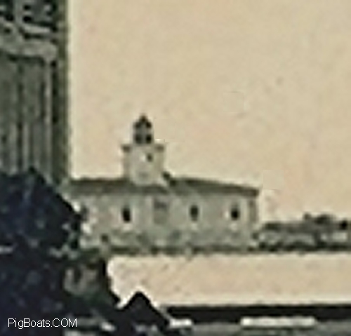
This close-up of the lighthouse is very grainy but it does show some of the architectural charm of the structure. The cupola holding the light dominates the roof-line.
From A Photo in the collection of Ric Hedman
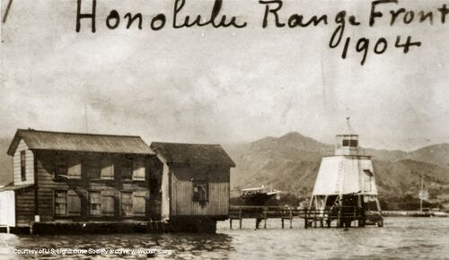
At the inner end of the Honolulu channel was the Honolulu range light shown here in a September 21, 1904 photo This is the light that will be replaced by new building seen below. The attached structure was undoubtedly for a light keeper lodging. A clipper bowed hulk can be seen between the building and light structure.
Courtesy of U.S. Lighthouse Society archive

It has been a long hard search and still no clear photo but we have finally come up with a set of lines drawings that are located in the National Archives for the "Front Range Light" as proposed on October 6, 1906. Later to be popularly known as the Honolulu Harbor Light Station. This being the Front elevation facing the harbor and the island itself.
The drawing propose a building showing Greek columns and pilasters and made from concrete block and poured cement. Whether the building was built as proposed is not discovered as of yet. There are no close up photos showing construction of that detail to be had at this time. The building was painted white to ward off tropical sun and an metal tile roof of an unknown color.
The station was built to accommodate two light keepers and their families in side by side, mirror imaged residences that shared a single bathroom and toilet facility. The light itself sat atop the roof at approximately 42 feet off of the Mean Water level. Tides in this area of the Pacific being only around 3 feet in rise and fall.
Drawings courtesy of Thomas Tag of the US Light House Society
Drawings in the US National Archives

This is the End Elevation with the Front of the building to the Right. The Entrance and Bath Room roof lines can be seen as gables on the main roof. The light tower, built of of poured concrete, can be seen to be located to the right or shoreward side of the roof peak.
The chimney for the Kitchen cooking range is seen at the back of the main structure. Concrete pilings in the foundation are buried 6 feet into the soil base of the island. Mean High Water and Mean Low Water marks are noted to the left side of the drawing.
Drawings courtesy of Thomas Tag of the US Light House Society
Drawings in the US National Archives
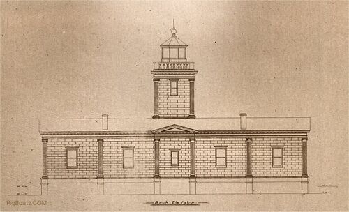
This is the Back Elevation showing the smaller window in the Bath Room Extension. The Bath Room was a shared facility between the two residences.
Drawings courtesy of Thomas Tag of the US Light House Society
Drawings in the US National Archives

This plan view shows the interior layout with the mirror image residences. The light tower base and a storeroom separate the two giving a measure of privacy.
At the rear, opposite the Bath Room, were the coal bins used by the families for cooking and being close by the Kitchens for ease of use.
Drawings courtesy of Thomas Tag of the US Light House Society
Drawings in the US National Archives

The first image shows the lighthouse front. The side facing the harbor of Honolulu. The place where much of the land that the lighthouse is sitting on came from. The differences from the lines drawings and the as built photos shows the front no longer has the gable end over the door. Probably to save construction monies. The small building with the flat roof this the oil storage building providing fuel for cooking and heating plus oil for the beacon on top. The fluting in the pilasters has been removed in favor of a smooth surface.
Freshly planted trees are seen growing and blowing in the tropical winds. A picket fence surrounds the structure. Behind the buildings is the harbor entrance channel and to the right is the open Pacific ocean. The rough ground is reclaimed soil from the bottom of Honolulu Harbor.
To the left in the far background is the Young Brothers boathouse. The Young Brothers company is still in business today.
Photos Courtesy of the U.S. Coast Guard Historian's Office via Candace Clifford, Historian, U.S. Lighthouse Society archive

The Young Brothers boathouse with two of their launches seen moored in front of the building which is built on stilts on the side of the entrance channel. What appears to be the launch/tug "Louise" is on the left and the tug "Makaala" is on the right. Young Brothers is still operating today as a tug and barge company. This company was very instrumental in the recovery of the submarine F-4 after it sank at the mouth of Honolulu Harbor. Their tugs are noted in many of the salvage and recovery photos associated with the F-4.
Photos Courtesy of the U.S. Coast Guard Historian's Office via Candace Clifford, Historian, U.S. Lighthouse Society.
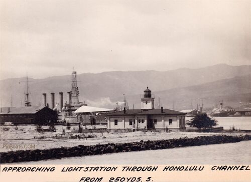
This is a 1915 view of the back of the building. The date is actually November 10, 1915. The center part protruding back is the single bathroom for the building. The two apartments shared a single bathroom. At this time bathrooms were still a "modern" invention. Most of the world still used outhouses. To have indoor plumbing, even sharing it, was still considered luxury. Not seen on the plans but evident in the photo are back doors and stairs.
The navy ship in the background is the USS Maryland (Armored Cruiser No. 8). Based on the date it is fair to say that she has just escorted some K-class submarines to Honolulu to replace the remaining 3 F-class and to tow the F-3 back to the mainland. The F-1 and F-2 were towed by other ships. The Maryland had brought the six pontoons from Mare Island to Hawaii for lifting the sunken F-4.
Photos Courtesy of the U.S. Coast Guard Historian's Office via Candace Clifford, Historian, U.S. Lighthouse Society archive
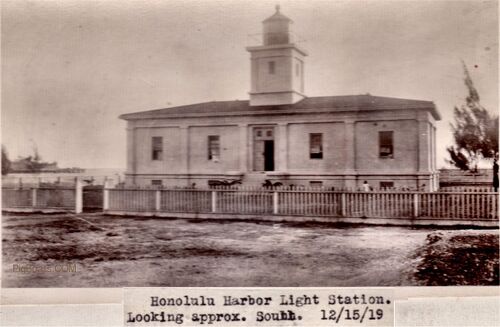
This December 15, 1919 view of the the Honolulu Harbor Light Station show several things. The most interesting is the presence of a small child playing in the yard. The child is seen to the right of the door and stairs and just to the right of the second pilaster. The detail is not there to determine if this is a girl or boy but what is clear is that at least one of the two light keepers who lived at the Light Station had a family with small children. The second interesting thing is there are two small palm trees now growing on either side of the bottom of the stairs. The tops can just be seen over the top of the picket fence. The Pacific Ocean is behind the building.
Photos Courtesy of the U.S. Coast Guard Historian's Office via Candace Clifford, Historian, U.S. Lighthouse Society archive
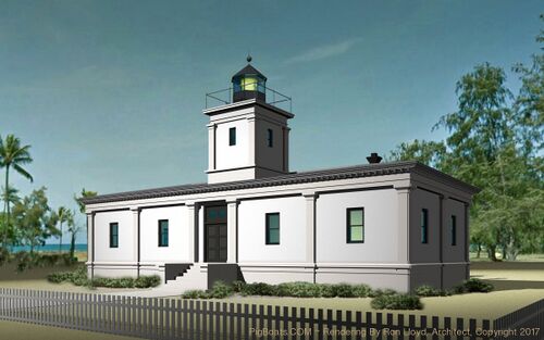
If there had been viable color photography circa 1915 this is probably what the Light Station would have looked like. Thanks to the rendering by Seattle Architect Ron Lloyd, using the drawings seen above, we have this color concept, made exclusively for PigBoats.COM, of how the building might have looked.
Lighthouse Rendering By Ron Lloyd, Architect, Seattle, WA © 2017, Made from Architectural Drawings Seen Above.
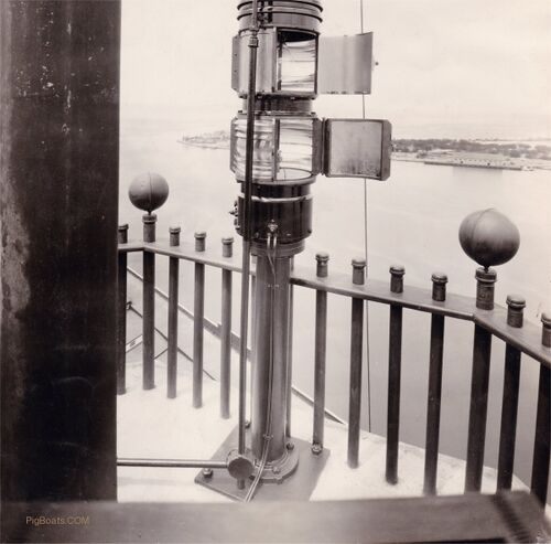
A view from the land based Range Light at the Customs House. The view shows the Quarantine Dock on the right side of the photo and to the left of the lights is the Honolulu Harbor Light Station. The photo is undated but it could be estimated to having been take about 1920 give or take a few years.
The electric light was the upper light and the gas light the lower one. If you look closely through the open door to the top lantern you can see the old clear light bulb that was used.
Photos Courtesy of the U.S. Coast Guard Historian's Office via Candace Clifford, Historian, U.S. Lighthouse Society.
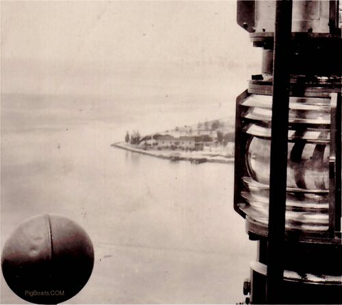
The detailed view from the beacon looking down on the Light Station with the lens of the lower gas lantern seen in some detail. As electricity was still new the more reliable "gas" light was included in tandem as a safety feature..
Photos Courtesy of the U.S. Coast Guard Historian's Office via Candace Clifford, Historian, U.S. Lighthouse Society.
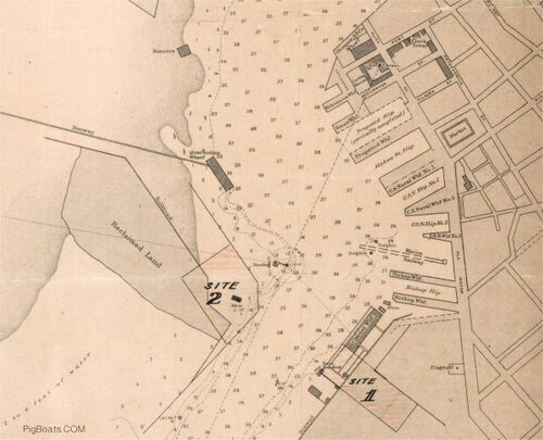
A Harbor Map from 1909 showing the proposed location of the Light Station and and piers. The location of the Ranging Light seen above can be seen at the end of the dotted line running from the bottom of the map and up to the shaded building cluster. The beacon was located just the north of the Customs House and east of the future location of the Aloha Tower. As noted on the map it is a Flashing Green beacon light.
Photos Courtesy of the U.S. Coast Guard Historian's Office via Candace Clifford, Historian, U.S. Lighthouse Society.
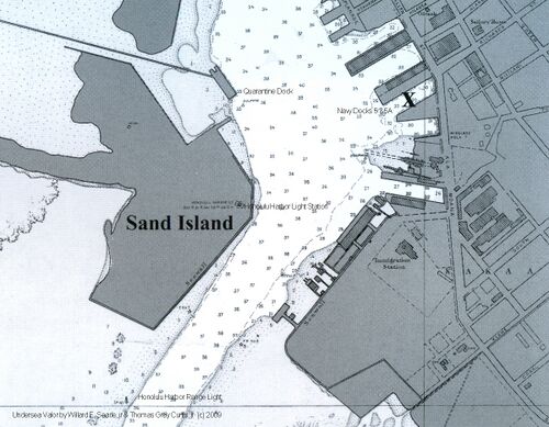
This map from the book "Undersea Valor" by Willard F. Searle, jr and Thomas Gray Curtis, jr, shows how Honolulu Harbor looked in 1915 when the Honolulu Harbor Light Station was in use. The shaded areas on the left are sand dredged up from the channel and harbor bottom to make the harbor a safe depth for all shipping using it. The Honolulu Harbor Light Station was built on this reclaimed land as noted on the map. The long causeway leading to the actual "Quarantine Island" from the Quarantine dock can be seen leading to upper left. There people with communicable diseases were housed on the island until cleared for entry.
Map Courtesy of 'Undersea Valor' by Willard F. Searle, jr and Thomas Gray Curtis, jr

Another photo taken after March 25, 1915 shows the F-3 and either the F-1 or F-2 moored to pier 5 in Honolulu Harbor. The Honolulu Light Station building can be seen in the background. An unidentified crewman stands on the deck of the F-1 or 2 perhaps talking to someone on another submarine barely seen at the edge of the photo.
At the left edge of the photo are several people in a skiff rowing around the harbor and looking at the submarines maybe talking to the crewman barely seen standing behind the bridge fairwater. His crooked arm is seen seemingly hand on hip. A light wind from the south is blowing the crews washing hung from a jackline strung between a spar and the bridge.
Photo in the Private Collection of Cory Graff, Author of "The Navy In Puget Sound"
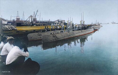
This colorized photo was taken at pier 5 in Honolulu Harbor, it was taken after the F-4 sank on March 25, 1915 killing all 19 crewmen aboard during a practice dive. The Honolulu Harbor Light Station can be seen in the background in this undated photo but the time of day this was taken looks to be mid morning based on the lighting on the photo.
The three submarines were prohibited from diving after the pressure hull collapsed on the F-4 from corrosion caused by a battery acid leak killing all 19 crew. The men are cleaning up the subs for a Captain's inspection. It was determined to send the three back to the mainland and replace them with the newer K-class submarine coming off the ways at this time. The ships used to tow the K-boats to Hawaii were used to tow these subs back to the mainland. The three F-boats left Hawaii in November 1915.
Photo in the collection of Ric Hedman
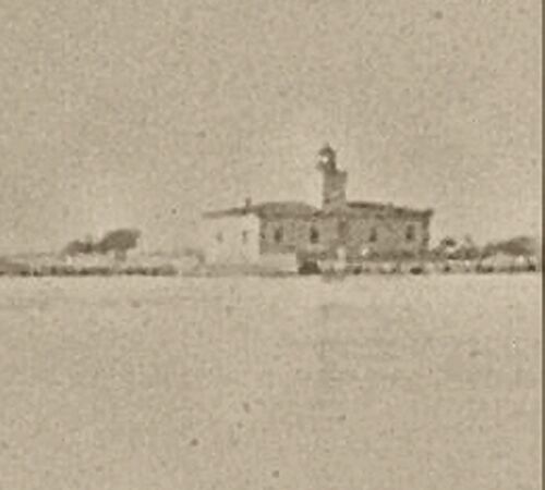
A close-up of the Honolulu Harbor Light Station from the photo above. A bit more detail can be seen but, again, it is not a very clear image. Time frame is circa mid 1915.
From A Photo in the collection of Ric Hedman

In this undated photo, provided through the generosity of the U.S. Lighthouse Society, a panoramic view of the harbor showing the Honolulu Harbor Light Station and the Quarantine docks. The view is from the direction of the landmark Aloha Tower in the Northwest end of Honolulu Harbor looking Southeast to the entrance at the left in the photo. Based on the lighting in the picture it looks to be a wintertime sunset going on.
The many shrubs and palm trees seen around the Light Station sustaining the claim that it was more than a mere light house and more a home to the lighthouse keepers stationed there.
Courtesy of U.S. Lighthouse Society archive.
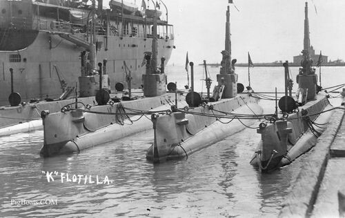
The F-class submarines were replaced by the more reliable K-class submarines, shown here moored at Pier 5A in Honolulu Harbor. From left to right are K-7 (Submarine No. 38), K-8 (Submarine No. 39), K-3 (Submarine No. 34), and K-4 (Submarine No. 35). Behind the right hand submarine is the Honolulu Harbor Light Station bisected by the periscopes. Just behind the ship you can see the open ocean as you look down the length of the harbor channel.
Photo in the private collection of Dave Johnston.
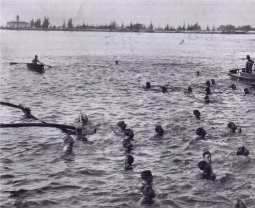
This Honolulu Harbor scene was typical for most of the 20th century. Young boys and men would greet passenger liners and dive for coins tossed in the water by the passengers. It was suppose to bring good luck to the visitors. An Ama of a outrigger canoe can be seen on the left. Interesting to note that among the Hawaiian native swimmers are what look to be 3 white men or boys looking for their chance at retrieving a coin or two.
In the background, on the left, is the Honolulu Harbor Light Station. The time frame is later than the previous images, maybe 1920, as is seen by the height of the trees and shrubbery. This in fact was to be one of the reasons for the demise of this light station. The growth of these trees, there by blocking the lights visibility from sea. A taller structure was needed and the light was removed and placed atop the newly built 'Aloha' Tower in 1926.
Snapshot In The Private Collection of Ric Hedman

This photo was taken on April 20, 1929 and shows the building with the lantern having been removed. This was placed on top of the newly constructed Aloha Tower. The building sits abandoned. On the right side the Oil House can be seen. In the foreground a workman helps dismantle forms used to pour a concrete pier on the Harbor side. The building stood until 1934 when it was destroyed. The Oil House stood for a number of years later.
Photos Courtesy of the U.S. Coast Guard Historian's Office via Candace Clifford, Historian, U.S. Lighthouse Society.
We hope you enjoyed this brief glimpse of a far too little documented structure that played a part in the early history of the USN Submarine Service, Hawaiian cultural lighthouse history, and of what was to become our 50th state.
Page created by:
Ric Hedman & David Johnston
1999 - 2023 - PigBoats.COM©
Mountlake Terrace, WA, Norfolk, VA
webmaster at pigboats dot com
